Mastering the Paris transport system’s internal logic is the single most effective way to avoid risk, bypass crowds, and travel with confidence.
- Switching to digital ticketing (Navigo Easy) eliminates key vulnerabilities at machines and gates.
- Proactive planning based on peak hours and strategic station positioning is more effective than passive awareness.
- Using built-in system tools like exit maps (“Plan du quartier”) and dedicated bike lanes allows you to bypass predictable and crowded tourist paths.
Recommendation: Actively navigate the system with purpose, turning potential friction points into tactical advantages for a smoother, safer journey.
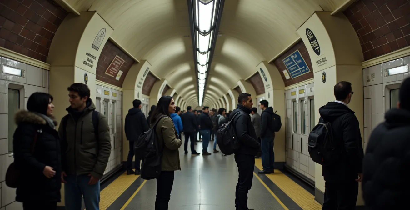
The crowded roar of a Paris metro car, the labyrinthine corridors of Châtelet-Les Halles—for many travelers, these moments are where anxiety peaks. The standard advice is predictable: “watch your bag,” “be aware of your surroundings,” “avoid distractions.” While not wrong, this reactive mindset keeps you perpetually on edge and, ironically, can make you stand out as a vulnerable tourist, constantly checking your belongings.
But what if the secret to safety wasn’t about clutching your wallet tighter, but about moving through the city with the fluid confidence of a local? This guide is not about fostering paranoia. It is about achieving system fluency. As a security consultant, I can tell you that the most secure travelers are those who understand and use the operational logic of the RATP network to their advantage. By thinking like the system, you become an unpredictable and undesirable target for opportunistic thieves.
This approach transforms your perspective. You stop seeing the metro as a threat and start seeing it as a complex but logical system to be navigated efficiently. We will decode everything from modern ticketing and peak hour avoidance to strategic transfers and intelligent exit strategies, empowering you to travel not just safely, but smartly.
For a visual perspective on common street-level tactics, the following video offers practical demonstrations on how to stay alert in crowded urban environments, complementing the system-level strategies discussed in this guide.
To help you master this system, we’ve broken down the essential strategies into distinct areas of focus. This guide will walk you through each element, from the ticket you buy to the way you exit the station, providing a complete framework for confident travel.
Summary: Navigating Paris Transport Safely and Efficiently
- Navigo Easy vs Paper Tickets: Why You Should Stop Buying Carnets?
- The “Sardine” Times: Which Hours to Avoid on the RER B?
- Châtelet-Les Halles: How to Transfer Without Walking for 15 Minutes?
- Sortie Numbering: Why Using the Map Inside the Station Saves You 10 Minutes?
- Front Window on Line 14: How to Experience the Magic of Notre-Dame While It Is Under Reconstruction?
- Funicular vs Stairs: Is the Metro Ticket Worth Saving Your Breath?
- Crit’Air Sticker: Do You Need One for a Rental Car Inside the A86?
- How to Cross Paris by Bike Using the “Pistes Cyclables” Safely?
Navigo Easy vs. Paper Tickets: Why You Should Stop Buying Carnets?
The single most significant friction point for a tourist is the ticket machine. Fumbling with cash or cards, trying to understand fare options, and dealing with a queue of impatient locals marks you as an easy target. The classic paper “carnet” of ten tickets is not only becoming obsolete but is a security liability. These tickets are prone to demagnetization if stored near a phone or hotel key card, forcing you back to the vulnerable position of buying another ticket. The RATP is actively working to phase out the 500 million paper tickets printed annually by late 2025, pushing users toward more efficient digital options.
The solution is to adopt the Navigo Easy card. For a one-time purchase fee of €2 at any station window, you get a durable plastic card that you can load with tickets digitally via machines or the Bonjour RATP app. This eliminates your interaction with ticket machines for the rest of your trip. Beyond the convenience, it’s a strategic move. A tourist confidently tapping a Navigo card at the turnstile blends in seamlessly, removing a key indicator of being an outsider.
The financial benefit reinforces the strategic one. An analysis of a typical 3-day tourist itinerary showed a spend of €20.40 on individual paper tickets. The same eight trips loaded onto a Navigo Easy card cost only €17.85, a saving of 12.5% while completely avoiding the risk of demagnetization. It’s a small investment for a significant upgrade in both efficiency and personal security.
The “Sardine” Times: Which Hours to Avoid on the RER B?
“Avoid crowds” is generic advice; a security professional’s advice is to understand and anticipate crowd dynamics. On high-traffic lines like the RER B, which connects Charles de Gaulle Airport to the city center, extreme crowding is a constant threat vector. It provides perfect cover for pickpocket teams. True environmental awareness means knowing the specific “sardine times” to avoid. According to the operational schedule, peak hours are not just a vague “rush hour” but are precisely defined. The most intense periods are from 07:00 to 09:45 in the morning and from 16:00 to 20:00 in the afternoon, when up to four trains run every 15 minutes to manage the flow.
If your flight lands at 08:00, waiting an hour at the airport for a coffee can mean the difference between a comfortable journey and being pressed into a carriage with no personal space. The same logic applies to evening travel. This isn’t just about comfort; it’s about control. In a less crowded car, you can choose where to stand, keep your luggage close, and maintain a clear line of sight, drastically reducing your vulnerability.
The crowding isn’t uniform across the line. To plan effectively, it’s crucial to understand where the pressure is highest. This data provides a clear picture of the line’s daily rhythm, as shown by an analysis of RER B traffic patterns.
| Time Period | CDG-Gare du Nord | Central Paris | South to Universities |
|---|---|---|---|
| 7:00-9:45 | Very High (Airport + Commuters) | Extreme | High |
| 10:00-16:00 | Moderate | Low-Moderate | Variable (Class Times) |
| 16:00-20:00 | High | Extreme | Very High (Students) |
| After 20:00 | Low | Low | Moderate (Events) |
Châtelet-Les Halles: How to Transfer Without Walking for 15 Minutes?
Châtelet-Les Halles is the heart of the Paris metro, and for many, it’s a source of dread. This sprawling underground complex is a prime example of where tourists become disoriented, slow down, and make themselves vulnerable. The long, winding corridors are notorious hunting grounds. However, for those with system fluency, Châtelet is just a node to be navigated efficiently. The secret is not to follow the herd but to use strategic positioning before you even exit the train.
The station is designed with color-coded corridors and optimized transfer paths, but these are only effective if you start in the right place. Knowing which train car to board is a high-level skill that saves immense time and reduces exposure in crowded tunnels. Instead of wandering aimlessly following generic “Sortie” (Exit) signs, you move with purpose from platform to platform.

This abstract view represents the flow of movement. Your goal is to be on the most direct path, minimizing time spent in the transitional spaces between lines. For a station this complex, a few key positioning rules can make all the difference.
Action Plan: Strategic Positioning at Châtelet-Les Halles
- For Line 1 to RER A/B: Position yourself in the front two cars when arriving from the La Défense direction. This aligns you directly with the fastest transfer corridor.
- For Line 4 to Line 1: Board the middle cars of the train and, upon exiting, commit to following only the orange corridor signs. Do not get distracted by other signs.
- For RER B to Line 4: If arriving from the north (like CDG), exit from the rear cars of the RER train and follow signs for the “Porte Lescot” exit corridor.
- Alternative Strategy: For connections between RER B and Lines 4 or 5, consider transferring at Gare du Nord instead. It is often less chaotic and more straightforward than Châtelet.
- Time-Saver Rule: Always allow a baseline of 8-10 minutes for any transfer within Châtelet and stick to a single color-coded sign path from start to finish to avoid looping back.
Sortie Numbering: Why Using the Map Inside the Station Saves You 10 Minutes?
A common mistake travelers make is thinking the challenge is over once they’ve swiped through the exit turnstiles. In Paris, emerging from the wrong exit can leave you on the opposite side of a six-lane boulevard, facing a 10-minute walk to a safe crossing just to get to your destination. This is another friction point where a disoriented tourist, staring at a map on their phone, becomes a target. The solution is embedded in the system itself: the “Plan du quartier” map found inside every station.
This map is your most critical tool for a seamless transition from the underground to the street. It shows you not just the exit numbers but also where they emerge in relation to major landmarks, bus stops, and, most importantly, which side of the street they are on. Ignoring this tool and just following the nearest “Sortie” sign is a rookie mistake. A local or a savvy traveler decides on their exit number *before* they start walking.
The case of the Louvre-Rivoli station is a perfect illustration. A tourist heading to the museum might logically follow signs for Exit 1, which leads to Rue de Rivoli. This requires a 5-minute walk above ground to the main Pyramid entrance. However, the Plan du quartier reveals an unnumbered exit labeled for the “Carrousel du Louvre.” This path leads directly into the underground shopping center connected to the museum, bypassing street-level weather and, crucially, the main entrance queues. This single piece of proactive navigation can save 15-20 minutes during peak season and keeps you in a secure, controlled environment for longer.
Front Window on Line 14: How to Experience the Magic of Notre-Dame While It Is Under Reconstruction?
System fluency isn’t just about avoiding risk; it’s also about leveraging the system’s unique features for better experiences. Line 14, the first fully automated, driverless line in Paris, is a prime example. For security, its efficiency is a major asset. As the RATP Group notes, it was a groundbreaking innovation in public transport.
Line 14 is the world’s first 100% automatic wide-gauge metro line when it started up service in the heart of Paris, with an interval between trains of only 85 seconds during peak hours
– RATP Group, Metro and RER Innovation Report
This 85-second interval means platforms clear out quickly, reducing the time you spend waiting in a stationary crowd. The modern, open-plan carriages offer better visibility than older metro stock. But beyond security, the driverless design offers a unique vantage point. Standing at the very front window provides a pilot’s-eye view as the train snakes through the tunnels, a thrilling experience in itself.
While Notre-Dame Cathedral is under reconstruction and its immediate vicinity is restricted, you can use the transport system to find alternative, powerful perspectives. Instead of joining the crowds straining for a view at street level, take the RER C to Saint-Michel Notre-Dame. The platform exits directly onto the quay, offering a panoramic, ground-level view of the restoration efforts across the Seine. It’s a respectful, uncrowded, and moving way to witness history in the making, using the system’s own geography to your advantage.
Funicular vs. Stairs: Is the Metro Ticket Worth Saving Your Breath?
Reaching the summit of Montmartre presents a classic tactical choice. Do you take the stairs or the funicular? From a security perspective, the choice is about energy management and situational awareness. Arriving at the top breathless and exhausted from climbing 222 steps can make you less attentive to your surroundings in the crowded plaza in front of the Sacré-Cœur. The 90-second funicular ride, which costs one standard Ticket t+ (and is included in Navigo passes), gets you to the top effortlessly, allowing you to arrive calm and alert.
This isn’t just about physical effort. It is a calculated decision. The stairs offer fantastic photo opportunities but expose you to a longer, more strenuous path where you might be focused on climbing rather than on the people around you. The funicular is a controlled, enclosed environment for a short duration. Alternatively, the Montmartrobus offers a third option, taking a scenic route through the village and dropping you near the top with zero effort, also for the price of a single ticket.

The best choice depends on your personal energy levels and goals for the day. If you have a long day of sightseeing ahead, spending a ticket to conserve energy for the crowded artist’s square (Place du Tertre) is a wise strategic investment in your own alertness and security.
Crit’Air Sticker: Do You Need One for a Rental Car Inside the A86?
True system fluency extends beyond the metro and RER network. If you plan to rent a car, understanding Paris’s driving regulations is a critical, and often overlooked, aspect of a smooth journey. The primary rule to know is the ZFE (Zone à Faibles Émissions), or Low Emission Zone. This zone, which covers Paris and the dense area inside the A86 motorway ring, requires all vehicles to display a Crit’Air sticker indicating their emissions level. This isn’t an optional tourist guideline; it’s a legal requirement.
The good news for renters is that major rental agencies are legally obligated to equip their fleets with the appropriate stickers. However, you should always visually verify its presence on the windshield at pickup. The ZFE restrictions are active on weekdays from 8 am to 8 pm for a wide area of 79 municipalities within the A86 perimeter. Driving without a sticker during these times can result in a fine.
Furthermore, you must be aware of potential emergency measures. During pollution peaks, authorities can implement “circulation différenciée,” which can ban even compliant vehicles (like Crit’Air 2 or 3) overnight. These alerts are broadcast on the news and on traffic apps. Being unaware of these rules can lead to fines and significant travel disruptions, marking another instance where a lack of system knowledge creates a problem.
Key takeaways
- Proactive system mastery is a more effective security strategy than reactive paranoia.
- Switching to digital ticketing like Navigo Easy immediately removes you from a key point of vulnerability.
- Strategic planning around peak hours, station transfers, and exit locations is more impactful than simply “watching your bag.”
- True system fluency means understanding all transport modes, including driving rules and cycling infrastructure, to build a resilient travel plan.
How to Cross Paris by Bike Using the “Pistes Cyclables” Safely?
The ultimate expression of system fluency is knowing when to get off the rails entirely. Paris has undergone a massive transformation, building a robust network of “pistes cyclables” (bike lanes) that offer a fantastic alternative to the crowded metro. With a 240% increase in cycling traffic between 2018 and 2023, the city is embracing two-wheeled transport, and as a traveler, you can leverage this to your advantage.
Using a bike rental service like the public Vélib’ system or free-floating options like Lime and Dott allows you to bypass the underground network’s chokepoints completely. A 20-minute metro journey with a transfer can often be accomplished in the same amount of time by bike, but with the added benefits of fresh air and sightseeing. From a security standpoint, you are an independent operator, not part of a captive crowd. You control your speed, your route, and your personal space.
Safety is built into the new infrastructure. Major arteries like the Rue de Rivoli now feature wide, protected bike lanes separated from car traffic by physical barriers. These “coronapistes,” created during the pandemic, have become permanent fixtures, creating a safe and efficient cycling superhighway across the city. Learning the main bike axes is like learning the main metro lines. It provides a parallel network that gives you resilience and flexibility in your travel planning. If a metro line goes down, you have an immediate, effective alternative.
Frequently Asked Questions about Navigating Paris Transport
How are Paris Metro exits typically numbered?
Exits are numbered sequentially, often clockwise from the main street or following the street’s numbering direction. The “Plan du quartier” map inside the station is the best guide to understanding the layout for that specific location.
What information does the ‘Plan du quartier’ provide?
The neighborhood map shows exit numbers, their precise location on the street, nearby bus stops, taxi stands, major buildings, and which side of major boulevards each exit emerges on, which is critical for saving time.
Why does the wrong exit cost so much time in Paris?
Major boulevards like Saint-Germain or the Champs-Élysées can be very wide and difficult to cross. Choosing the wrong exit can force a detour of 5-10 minutes just to find a safe pedestrian crossing, as some exits are over 200 meters apart.
Do rental cars in France come with Crit’Air stickers?
Yes, major rental agencies are legally required to equip their fleet with the appropriate Crit’Air stickers for the vehicle type. However, it is always a good practice to visually verify the sticker is on the windshield when you pick up the car.
What happens during pollution peaks?
During high-pollution episodes, authorities can trigger emergency “circulation différenciée” measures. These measures can temporarily ban even vehicles with compliant stickers (like Crit’Air 2 or 3) from driving within a wide perimeter, often active 24/7 until the alert is lifted.